Sargent station
Sargent | |
|---|---|
 Sargent Station | |
| General information | |
| Location | Monterey Road Santa Clara County, California, U.S. |
| Coordinates | 36°55′10″N 121°32′53″W / 36.91944°N 121.54806°W |
| Line(s) | Coast Line |
| Platforms | 1 side platform |
| Tracks | 1 |
| History | |
| Opened | 1869 |
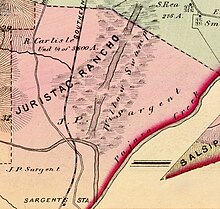
Sargent station was a railroad depot for Sargent, California. The station stop was established in 1869 when the Santa Clara and Pajaro Valley Railroad extended its line to Sargent. Located near the mouth of Pescadero Creek and adjacent to the Sargent Ranch, the station was named after James Pattee Sargent, who owned the Rancho Juristac Mexican land grant and served in the California State Assembly representing Santa Clara County.
History[edit]
Prior to 1769, the site was inhabited by approximately 2,700 Amah Mutsun Ohlone Indigenous peoples who lived in villages along the Pajaro River before the arrival of Spanish colonizers who settled in Alta California. Today[when?] most of the over 500 members of the Amah Mutsun band are descendants of the native people who were later baptized at Mission San Juan Bautista.[1] Spanish explorers led by the military officer Juan Bautista de Anza and Pedro Font (missionary) first passed through the Santa Clara Valley area in 1776. Later, in 1797 Mission San Juan Bautista was established near the Pajaro River.[2] In 1835, Antonio and Faustino German were granted, by Governor José Castro, the 4,540-acre (18.4 km2) Mexican land grant Rancho Juristac.[3]
In 1856 James Pattee Sargent (1823–1890), a rancher and assemblyman, bought Rancho Juristac with his brothers, where he established his residence, later known as Sargent Ranch."[1]
Passenger service[edit]


The Sargent station opened in 1869 under the Santa Clara and Pajaro Valley Railroad making Sargent Station a railway stop near Sargent Ranch, owned by rancher and former assemblyman James Pattee Sargent. A year later, the line was acquired by Southern Pacific Railroad.[4][5]
By 1872, southern destinations could be reached daily by taking the Southern Pacific railroad to Gilroy, continuing to Sargent's Station, and then proceeding by stagecoach.[6] By 1890, the Monterey Express stopped at Sargent Station to allow passengers to continue by stage to San Juan and Hollister.[7]
There were several train crashes at Sargent Station. For instance, on November 12, 1906, the engine boiler of the Sunset Limited train No. 10 exploded at Sargent's Station, setting the station building on fire.[8] In 1897, Del Monte Express struck a bowlder, causing damage and derailing one of its cars.[9] By 1945, Southern Pacific Railroad Coast Line timetables indicated that stops at Sargent station were made on signal for passengers traveling to Los Angles and other destinations.[10]
Freight stop[edit]

Sargent Station was a key site for shipping oil along Monterey Road to San Jose. Around the turn of the century, the Watsonville Oil Company began extracting oil from the Sargent Ranch oil field. By 1864, an oil and kerosene distillery was operating at Sargent Station. When the company ceased operations in 1948, it had shipped 780,000 barrels of oil from the station.[1][11]
In 1949, the Union Sugar Company established a beet loading station in Sargent. To accommodate this, Southern Pacific constructed a new spur track to serve the loading station. Beets were transferred from trucks into the train cars. The sugar beet loader has been abandoned but can be seen along Highway 101 near the town of Sargent.[12] As of 2024, the former site of Sargent station is marked by a sugar beet loading conveyor along the Union Pacific Railroad track west of U.S. 101. The station's rail siding and the second track are overgrown and disconnected from the main line.
References[edit]
- ^ a b c Hart, Richard E. (2019). "Federal Recognition Of Native American Tribes: The Case Of California's Amah Mustsun" (PDF). www.protectjuristac.org. pp. 66–67. Retrieved May 21, 2024.
- ^ "Local Landscape Descriptions" (PDF). San Francisco Estuary Institute. pp. 199–200. Retrieved May 16, 2024.
- ^ Hoffman, Ogden (1862). Reports of Land Cases Determined in the United States District Court for the Northern District of California. San Francisco: Numa Hubert. Retrieved May 31, 2024.
- ^ Hart, Richard E. (2019). "Federal Recognition Of Native American Tribes: The Case Of California's Amah Mustsun" (PDF). www.protectjuristac.org. pp. 66–67. Retrieved May 21, 2024.
- ^ Pierce, Marjorie (1981). East of the Gabilans The Ranches, the Towns, the People--yesterday and Today. Western Tanager Press. pp. 150–152. ISBN 978-0-934136-11-2. Retrieved May 16, 2024.
- ^ "Paso Robles Hot Sulphur Springs". The San Francisco Examiner. San Francisco, California. March 9, 1872. p. 2. Retrieved May 22, 2024.
- ^ "Salinas Daily Journal". The Californian. Salinas, California. March 30, 1890. Retrieved May 29, 2024.
- ^ "Uncle Collis' Carless Men. Very Serious Train Wreck at Sargents Station is Narrowly Avertd". The San Francisco Examiner. San Francisco, California. September 6, 1897. p. 4. Retrieved May 29, 2024.
- ^ "Wrecked On Rails. Engine Boilder Explodes at Sargent's Station and Wrecks Depot". The Los Angeles Times. Los Angeles, California. November 12, 1906. Retrieved May 29, 2024.
- ^ "Southern Pacific RR Coast Line Time Tables". December 1945. Retrieved May 30, 2024.
- ^ David L. Wagner; Bill Fedasko; J.R. Carnahan; Ross Brunetti; Leslie B. Magoon; Paul G. Lillis (2002). "Tar Creek study, Sargent oil field, Santa Clara County, California". Sacramento, California: California Department of Conservation, Division of Oil, Gas, and Geothermal Resources. p. 17.
- ^ "Union Sugar Adds New Beet Lading Station". The Californian. Salinas, California. May 21, 1949. p. 20. Retrieved May 24, 2024.
